

UrbanSim is an open source urban simulation model used to simulate the spatial distribution of urban growth at various time-intervals in the future to assist South Africa’s major metropolitan regions to anticipate and effectively accommodate spatial change. This is done by simulating various policy scenarios and using the results to assist planners with evaluating the impacts of policy.
The components of the UrbanSim model are designed so that the choices made by households, businesses, developers and government, as the key actors in the urban development process, are reflected in the simulated scenarios. As such UrbanSim is an analytical tool used by planners and decision-makers to evaluate the potential consequences of policy initiatives and infrastructure investment choices.
Mathematical and theoretical models, such as UrbanSim, used for urban simulation and modelling were introduced as a response to increasingly complex urban systems encompassing components such as: economies, space, social and political structures, transportation as well as other infrastructure systems and technologies which are ever evolving. This model is therefore seen as a tool that can help drive urban development that is economically, socially and spatially sustainable.
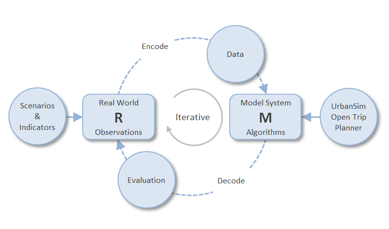
The essence of urban modelling to achieve this objective could be described (Figure 1) as a process of encoding part of the real world R into a model system M, running the model a number of times to simulate specific policy scenarios 30 years into the future and then evaluating (predetermined) indicators of land use change as the outcome of each scenario.
The term policy scenario is used here in a very specific way: it is a unique combination of policy alternatives and assumptions, such as estimates of the growth (or decline) of population and employment in the study area. Policy alternatives may include anything from growth boundaries, zoning and building density restrictions to strategic decisions about transportation and other infrastructure systems.
The term indicator is also used in a specific way: it refers to any data field or variable calculated from one or more data fields in the UrbanSim database. One or more indicators could be used to assess the relative worth of different policy scenarios or could simply be defined and used to make sense of the simulation results.
A trivial example may help to explain this. An “Urban Growth Boundary” may be considered as a means (policy) of achieving higher development densities and restricting development to areas where municipal infrastructure can be provided in the most cost effective way. One could therefore specify two policy scenarios: the usual trend scenario without the growth boundary and a ‘densification’ scenario with the growth boundary. As far as UrbanSim is concerned, the only difference between these scenarios is that it will not allow construction outside the growth boundary. When both scenarios have been simulated, officials evaluate the likely outcomes by comparing one or more indicators. In this trivial example, the indicator could be as simple as comparing the average development density expressed as housing units per hectare.
For more information contact:
Quinton van Heerden, CSIR
qvheerden@csir.co.za