


The effective delivery of social services in rural South Africa remains a major challenge especially outside of metropolitan areas and on the urban periphery. On the supply side, challenges include the poor planning and location of facilities, uncoordinated government investment and the need to ensure sustainable and effective service delivery within a resource scarce context. On the demand side the challenges are to provide facilities in a manner that is spatially just and equitable within the context of fast growing town and settlement population, with changing demographic profiles, extensive sparsely populated areas living in different settlement configurations and patterns as well as varied levels of mobility and access to social facilities.One of the key challenges identified was the need for greater differentiation of service types to clearly link facility levels to different contexts to enable improved location and distribution of facilities to achieve greater service efficiency and viability in areas with limited demand or with poor accessibility. One means of achieving this is through greater spatial profiling that enables facility investment to be more closely aligned to service need in terms of demographic distribution with respect to population distribution and density. Goal is to enable effective, just and more sustainable service delivery of services in all areas especially those with limited demand and accessibility.
In response to this challenge, the Department of Rural Development and Land Reform commissioned the CSIR to explore and develop differentiated provision standards for locating a wide range of government provided social facility types in non-metropolitan municipalities. The project was undertaken during 2015-2016 with a specific focus on developing differentiated provision standards that can be used to improve access to services and to ensure that facilities are not underutilised or unsustainable. A key part of the project was to test the impact of and potential to spatially target and rationalise the investment of middle and higher order facilities to minimise the number of service points while maintaining a high level of service coverage in order to contribute towards greater efficiency and cost saving which at the same time improving spatial distribution and service reach in rural areas.
However, the key considerations in improving facility provision of government services remains that the provision should be socially just, equitable and sustainable as well as efficient and operationally viable. The implication of this is that the approach to rationalising or spatially targeting facility provision must consider and ensure:
- Acceptable levels of access and distances to such facilities, especially the most vulnerable (considering the agreed standards);
- Sustainable resource allocation through strategic location choices within the widely diverse and vast rural settlement landscape to ensure that a high percentage of the population is served;
- Enhanced impact of government investment by aligning and prioritising investment of different departments within the same local precincts;
- Government investment should positively contribute to (and not dissipate) town and settlement consolidation, growth and local economic activities through sound location choices.
In order to contribute towards answering these questions within a context of diverse levels of facility provision differentiated standards and widely differing settlement morphology and growth, the CSIR Urban and Regional Planning team identified the need and value to undertake a research project to determine which towns and villages (outside of the major metros) would be best located to serve the most people from the least number of service points with respect to middle to higher order social facilities while still achieving a high level of service coverage (over 90%) within acceptable travel distances and without service catchments overlapping each other unduly.
The purpose of this overview is to provide some insight into the outcomes of this research, the most significant findings, as well as a brief overview of the approach that is used in the identification of the priority places. The findings of the research have been made available for public use, in support of the DRDLR’s project on Guidelines for the Differentiated Provision of Social Services in Rural Areas. For more information please logon the Social Facility Provision Toolkit. See resources text box below.
The prioritised town locations and the respective areas within service reach of the priority towns are shown in the accompanying animated graphic. The graphic indicates the relationship between a number of core service points versus the percentage of population within reach for towns of different levels of priority assuming only one service point per service area.
Prioritization analysis outputs
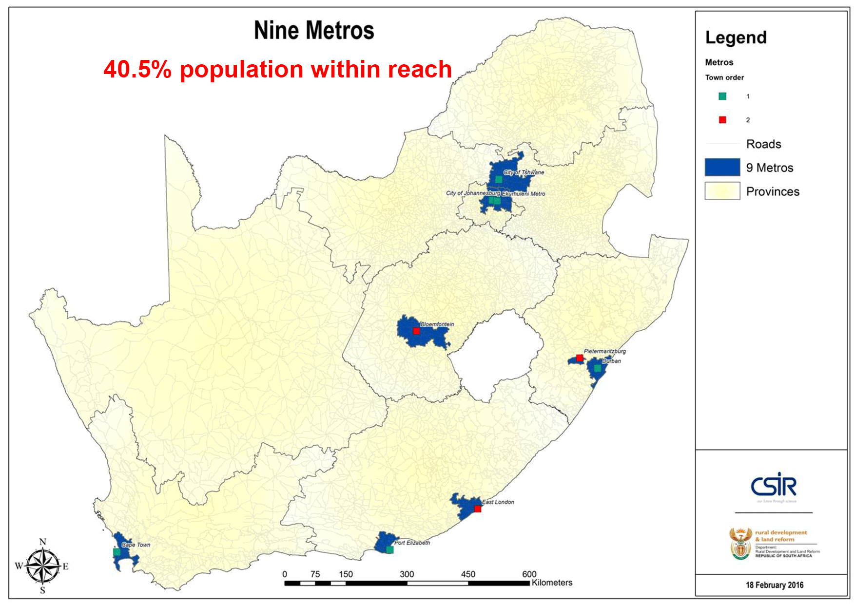
Spatial targeting and service reach for middle to higher order services (Source: Green, et al. 2016).
The implication of spatially targeting prioritised towns that optimally reach areas of 30 km or less (but up to 50 km in sparse areas i.e. Northern Cape) with no overlap of the service catchment area, is that it is possible to achieve high service coverage of 91.4% whilst minimising the number of prioritised service distribution points to 378 metropolitan regions, cities, regional service centres, towns and villages. The analysis has implications for service provision throughout the country as the places identified for middle-order service location mean that government service providers can, through location and alignment of services at the identified towns, achieve a very high service reach using fewer locations rather than trying to provide services where there is insufficient demand for optimal service viability and sustainability or where service areas overlap unnecessarily.
If a spatially targeted investment strategy is used to locate middle-order services in the selected and identified places, it reduces the number of potential points requiring services by over 50%, while still being within an acceptable travel distance of over 90% of citizens, including those living in rural areas. Thus, it is in the provision of clustered, integrated and spatially aligned and targeted provision of middle-order services that the opportunity exists to direct social and government investment optimally outside the metros and to rationalise services while ensuring service coverage to a far greater number of people. This approach when applied diligently over a successive number of years could achieve a more efficient allocation of resources that should have considerable cost saving implications which are critical given the expected continued pressure on the South African finances within the medium term and specifically given the anticipated increase in population growth within the next 30 years.
This analysis output proposes a geo-spatially targeted hierarchy of places that can be used to prioritise investment in social and government services of (regional) middle-order facilities in integrated government precincts that is equitable, considers access distance standards and is spatially fair to potential users. Priority places can be identified using the Social Facility Provision Toolkit and its lists of towns, catchments and identified list of prioritised places. See here. For more information on the priority places and the profile information for all the service catchment areas, please access this free web-based Toolkit which is spatially relevant. Given the potential impact of this analysis, the results have been incorporated and considered in the development of the new South African Town Typology as well as in the proposals for settlement concentration and densification in the National Spatial Development Framework through identification of Rural Anchor Towns.
In order to define service catchments for facilities, principles of central place, agglomeration, and accessibility were used to define service catchments around 1328 identified places in the country. The service catchments serve as the focus point for the planning of the demand and location for all social facilities. GIS tools such as network and service catchment area analysis, were applied to, firstly define the service catchments around all towns for which that town was the closest service point. Each of the catchments was profiled with respect to a range of demographic information. This together with the CSIR/SACN 2010 Settlement Typology was used to undertake a preliminary ranking of catchments. A description of the detail approach and technical GIS processes followed can be found on the documents tabs of the Social Facility Provision Toolkit. The profile information for each of the service catchments can also be accessed.
The same accessibility and GIS analysis tools were also applied for the optimisation process to identify which towns and villages outside of the major metros are best located to serve the most people from the least number of service points with respect to middle to higher order social facilities that have a service reach of up to 30km in densely populated areas and is extended to 50km in more sparsely populated areas. This is in accordance with the standards as described in the Guidelines for the Differentiated Provision of Social Services in Rural Areas.
Local facilities such as schools and parks, need to be provided in most areas and within five kilometres or less from their users. On the other hand, middle to higher order facilities such as 24-hour health services (community health centres or hospitals), Home Affairs and Labour offices, regional sport facilities, libraries and police service offices have a greater access distance threshold. This presents a major opportunity to rationalise and spatially target the location of such middle to higher order facilities. These facilities have similar distance thresholds for services. The access distance threshold is typically 25/30km in most areas and is extended to 50 or 100 km where the population around towns is less dense and drops below 10 persons per km2. (The access distance can be much shorter in urban areas and is typically 15km in metro areas and large cities where higher densities mean greater operational efficiency within shorter access distances.)
The fact that these middle order facilities have similar access distance and location criteria, presents the opportunity to use optimisation analysis to spatially target or prioritise towns that have the greatest potential for optimal location of middle order services. Within these places these middle order facilities should be clustered and spatially aligned for greater user comfort, reduced trip making and in order to contribute positively to urban development.
The spatial optimisation analysis is based on the geographic accessibility of a potential service point (or node) to the largest proportion of the population within the shortest distance. The GIS analysis was done taking into consideration that there should be minimal or no overlap within service areas of such identified service points. With this in mind, the access distance around the town points was specified as 30km road access distance in areas of medium to high population density and 50km in less dense areas The routine was programmed to consider service catchment population size, density and concentration within a particular radius and then to evaluate and rank the results. The ranking identified potential optimal prioritised service locations to serve the entire country without having overlapping catchments. The result of the prioritisation is the selection of the most central / accessible places for middle order service roll-out and provision. The proposition is that these selected towns can serve as points for integrated, spatially aligned inter-governmental service delivery investment where the most people could potentially access middle order services from the least number of service points. These services should preferably form part of government precincts.
For the optimisation analysis process of the whole country, use was made of the CSIR Mesoframe population data layer for 2011 available here. The population centroids of the 25 041 mesozones were used as the origins for the population who need to access the services (demand) while 1 328 identified service points were considered as the potential supply points. The 1 328 points were selected based on identifying nodes (villages, towns and cities) which have significant and critical private sector and government activity already present.
However, not all the 1 328 potential service points had to be ranked based on the optimisation analysis. Several of the points are already well established and accepted service points with significant and ongoing government investment or having significant economic activity. These places were identified by using the CSIR/SACN 2010 Town Typology. Towns classified as Service Towns or above were all selected or where no Service Town was identified, the most economically significant small towns of regional significance was identified. In cases where two or more Service Towns were in competition for the same catchment population, the most significant or largest town was selected heuristically. This resulted in 184 points being pre-selected service points based on the fact that these points were or should already host middle order services due to either their government defined administrative role, regional significance or their natural evolution as economic hubs in the bigger region in which they are situated. The next step in the analysis process was to define road network-based service areas around the pre-selected 184 places where service catchment areas did not overlap. Then followed the prioritisation and ranking of the remaining service points based on the number of ‘unserved people’ not falling within reach of the 184 places within 30km (adjusted to 50km for sparsely populated areas) without any overlap in service areas. The optimization analysis process thus selected the remainder of the 1 144 towns outside the areas already serviced by the pre-selected 184 points which have the greatest potential to act as service integration points for middle order services. This was an iterative selection process with the optimisation routine sequentially selecting the next most optimal towns from the remaining unserved areas. The selection was based on the number of people and population concentration within the distance cut-off, as long as at least 5000 people were found within the specified distance and the point did not already fall within a serviced area. Once a point was selected, the model searched for the best remaining potential service points in the unserved area; all the while continuing to not allow service areas to overlap.For more information, please see the technical report available here
- Green, Chéri, Mans, Gerbrand, Ngidi, Mawande, Sogoni, Zukisa, Maritz, Johan. 2016. Using Catchment Areas Analysis and GIS based Spatial Analysis for Prioritising Spatial Investment in Non-Metro South Africa. ISOCARP Durban, 12-16 September 2016. Available here
- Mans, G., Green, C., Ngidi, M., Sogoni, Z & McKelly, D. 2016. Development and Prioritisation of Catchments. Technical report commissioned by the Department of Rural Development and Land Reform. Available here
- The CSIR Typology of Functional Towns
- CSIR Guidelines for the Provision of Social Facilities for South African Settlements
- Guidelines for the Differentiated Provision of Social Services in Rural Areas
- Social Facility Provision Toolkit
Contributors & Ackknowledgements:
Acknoweldgement:
- DRDLR Rural Standards
- CSIR Social Facility Allocation Standards
- CSIR Update of the socio-economic data, typology and Mesoframe
Contributors:
- Chéri Green, Zukisa Sogoni, Gerbrand Mans, Elsona van Huysteen, Dave McKelly, Johan Maritz
Other resources and links:
- CSIR Town Typology
- Social Services Provision for South African Settlements
- CSIR Guidelines for the Provision of Social Facilities for South African Settlements
- Social Facility Provision Toolkit
- Guidelines for the Differentiated Provision of Social Services in Rural Areas