


The CSIR Functional Town Typology has been developed with the specific purpose to provide a fine grained, but nationally comparable overview of regional scale settlement patterns and trends. The latter provides a mechanism to identify, calculate and analyse a set of development information and trends pertaining to the range of towns and cities, as well as high density rural settlements across South Africa. It enables profiling of specific settlements or the analysis of demographic and economic trends of a set of settlements with similar scale and type. The typology enables calculating the population and the economy of functional town areas, comparing town areas relative to non–town areas and for exploring regional and spatial inter-relations. It also enables temporal and spatial comparison at a regional scale of settlements independent of municipal boundary demarcation.
The share of Africans living in urban areas is projected to grow from 36 percent in 2010 to 50 percent by 2030. The continent's urbanization rate, the highest in the world, could either lead to economic growth, transformation, and poverty reduction or increased levels of poverty if the right policies are not implemented. This trend also holds true in the South Africa context. Although much of the growth is in established and recognised towns and cities there is also a growing trend of concentrated settlement formation in areas commonly seen as rural.
Shaping an urban and urban-in-rural future and actively harnessing the urban dividend in an increasingly uncertain and volatile context such as South Africa requires more than mere tracking and reporting increasingly standardised indicators. It requires identifying relevant patterns, probes and framing conditions and thus, understanding the dynamics, patterns and risks associated with the functional and highly relational system of investment, use and movement within and between cities, towns and settlements.
In order to actively shape, adapt and transform the quality and future of settlements, it is critical to explore intra and inter-settlement patterns, trends, dynamics, as well as inter-relational and temporal shifts of the types of places and settlements that form distinct functionally linked places. The CSIR Town Typology was developed to explore settlement dynamics at regional and national scale, identifying functional town and settlement areas in the South African context, where firstly, official data are captured at municipal scale (where large municipal areas incorporates multiple settlements and rural areas), and secondly even where due to the apartheid legacy even where finer grained information is increasingly available:
- concentrated functional town areas are still not easily identifiable by name or a contiguous densely settled area of separated development of former Black and White township areas, and
- large numbers of people were excluded from formal urban areas and forced to live in high density rural areas where growth are often not regarded as ‘urban’ because of the traditional and formal nature thereof.
The spatial distribution of cities, towns and settlements based on the 2018 typology is shown in the map alongside. For a detailed definition of each settlement category type click here. It’s important to note that place names of the biggest and most well-known town/settlements are used for ease of reference and location identification and metro’s and secondary cities are included within the ‘city area’ category within the typology.
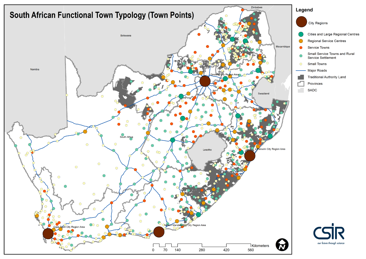
Figure 1: CSIR Town Typology 2018 (Update of the former SACN/CSIR Functional Settlement typology, 2013)
A breakdown of the number of settlements of each type as well as the numbers of people living in the various categories is shown in the figure below:
The latest 2018 typology is unique in that it further enables the separate calculation and analysis of the population and the economy of functionally linked areas relative to non – built up areas within each municipal area. The updated typology has had immediate impact though application in the Draft NSDF 2018 framework as well as the CSIR/IRDC Greenbook on Climate Change Adaptation (To be released 2019). The latter was a key stimulus and a contributor to the new South African Functional Town Typology 2018, as it increased the urgency for the demarcation of the settlement footprint and developing the open settlement layer for built-up areas across the country
For access to the spatial frame (mesoframe) and socio-economic indicators, click here .
The Town Typology forms part of a range of typologies developed by the CSIR together with a number of other role players, over the last couple of years. These typologies were developed to provide spatial planning evidence, analysis, modelling outputs to provide a platform support to government planning and development and with a focus on strengthening strategic regional, inter-regional and intergovernmental planning, resource allocation and monitoring and evaluation in South Africa.
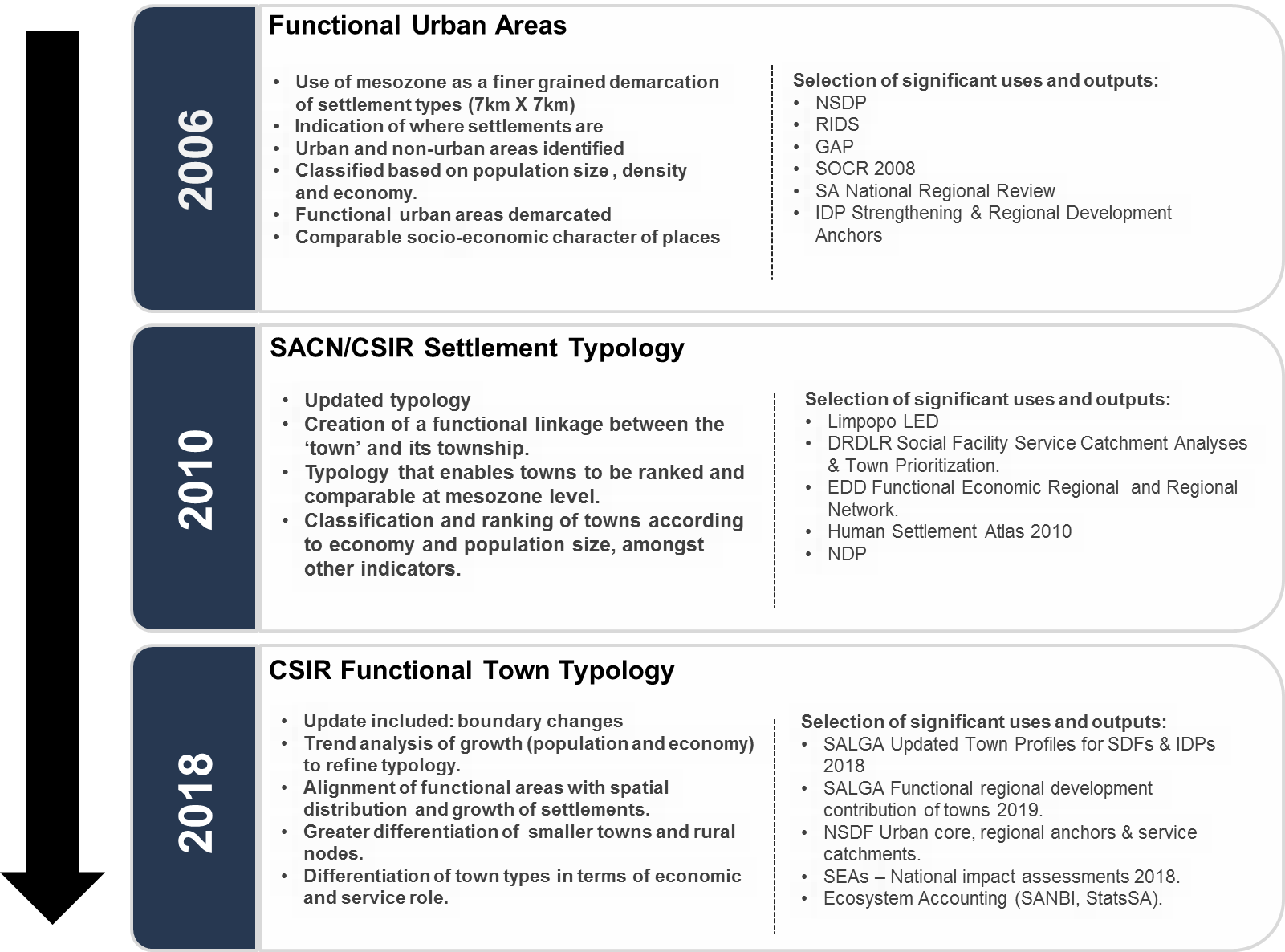
For access to a short write-up of process followed in updating the CSIR South Africa Functional Town Typology, see van Huyssteen, E. Green, C. Sogoni, Z., Maritz, J. and McKelly, D. South African Functional Town Typology (CSIR 2018 v2). Available here.
To download the South African Functional Town Typology 2018 data available at the Meso Frame level follow this link.
Using the CSIR Town Typology however, it is estimated that almost 79% of South Africa’s population of 55.8 million people, reside within cities and towns throughout the so-called urban and rural landscapes. It is calculated that by 2016 of the 42.7% of South Africa’s population resided within the four functional city region areas of Gauteng, Cape Town, eThekwini and Nelson Mandela Bay (as identified in the typology) and 10% lived within Cities and large regional towns, about 25% in a network of large and smaller service towns, and a further 18% of South Africans reside in ‘rural’ settlements , it is evident that South Africa needs to harness the future - to be addressed within its network of cities, towns and settlements.
Findings from recently conducted analyses also illustrate the crucial role that these populated places, and especially city region areas play as economic engines and job baskets within South Africa. An estimated 60% of the formal economy alone is being generated in the City Regions. We add to the City Regions the network of Cities and major towns this includes more than 83% of the total South African economy. Due to its value to provide nationally comparative overview, the functional town area demarcation and town profiling was also over time used extensively as basis to describe and compare cities and towns across South Africa, as well as town growth trends in support of government policy. This inter alia includes use within the Chapter 8 in the NDP, 2012; the IUDF, 2015, the SA Risk and Vulnerability Atlas 1 & 2; the SACN SOCR, 2016; the DRDLR Social Facility Toolkit, 2016 and most recently in the Draft NSDF, 2018 to develop settlement scenarios for the future.
For the old version of the typology (for historical context), please visit this link.
The typology was developed with a range of collaborators over time, including The Presidency, the SA Cities Network, the Department of Rural Development and Land Reform.
For more information on the updated South African Functional Settlement Typology contact:
Elsona van Huyssteen - evhuyssteen@csir.co.za
Johan Maritz - jmaritz@csir.co.za
- Urban settlement growth
- Growth implications for the Integrated Urban Development Framework
- South African Risk and Vulnerability Atlas
- A National Overview of Spatial Trends and Settlement Characteristics
- Advances in Spatial Analysis to Support a more Nuanced Reading of the South African Space Economy
| SA CSIR MesoZone 2018v2 |
|
| SA CSIR MesoZone 2018v2 Metadata |
|