
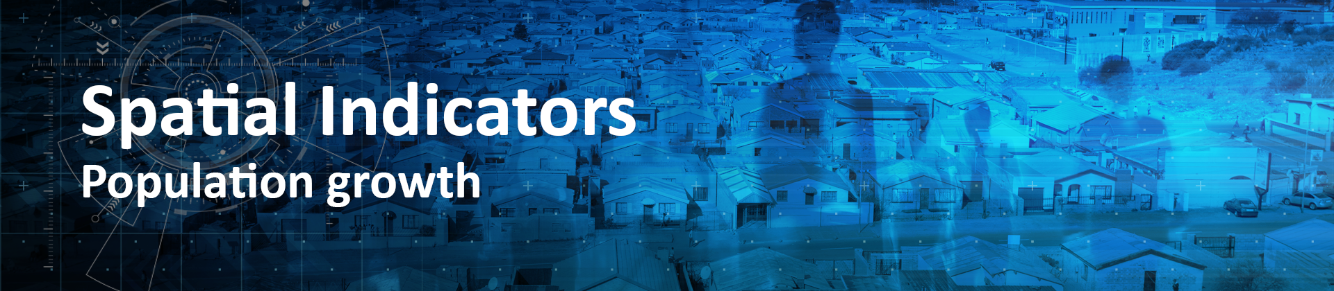

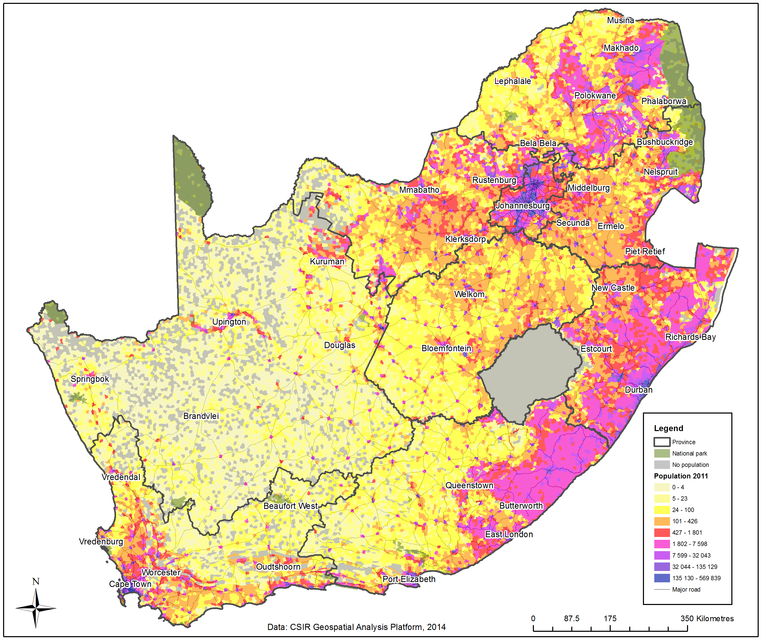
This indicator shows the change in total population (and gender split) over the last 15 years (1996 to 2011). This is the most fundamental indicator on population growth and decline for the country.
For an interactive views of the indicator click here
It is a fundamental indicator which allows the tracking of population growth and decline across South Africa. The value of understanding spatial specific trends of population concentration and growth has clearly been illustrated within national and regional planning in South Africa (See the Presidency and CSIR collaboration in using stepSA Regional Profiler already in 2010 to develop a Territorial Development Overview for SA). Read more >>
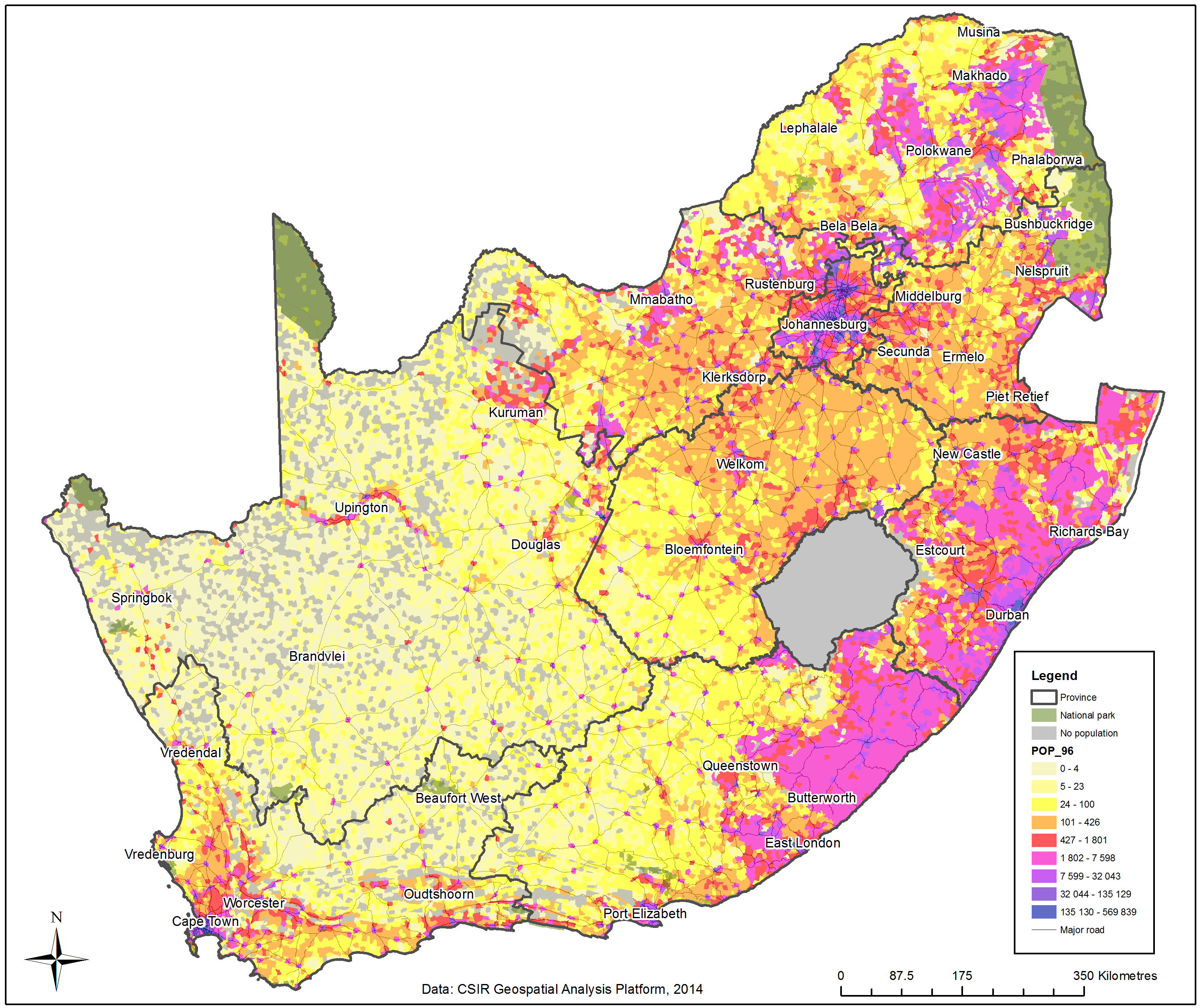
The latest innovation in spatially refined change indicators provides a new platform to understand the critical role and comparative significance of certain regions and areas in the in housing the country’s population and providing access to livelihoods and services. These functional regions, typically characterised by high population densities and continued population growth, both within so-called urban and rural areas, require specific consideration in terms of targeted service provision, investment, maintenance and governance responses. Population growth distribution patterns hold implications for the distribution of resources and services to ensure governance impact in terms of accessibility of services and improvement in quality of life.The population change indicator has been successfully used in 2014 to enable a settlement specific growth analyses for South Africa for the first time. Read more >>
This analyses also played a key role in informing the base analyses for the draft Integrated Urban Development Framework (IUDF) driven by the Department of Co-operative Governance (DCOG) with support for the urban growth analyses provided by the CSIR, Spatial Planning and System team and South African Cities Network. Read more >>
In some regions in the country there is a different dynamic in terms of population movement patterns when comparing the male and female population, the mining industry which draws a large number of younger males as the workforce comes to mind. The gender split was therefore selected to look into these types of phenomena.
By applying a geo-spatial analysis method based on the principles of dasymetric mapping, the variables have been disaggregated and reassembled to align the three censuses’ (1996, 2001 and 2011) population totals per mesozone (analyses unit). A short overview of the methodology behind the change indicator development has been prepared in support of the Department of Rural Development and Land Reform’s initiative to explore technologies and tools to provide information on land use change in 2014. Read more >>
- Department of Rural Development & Land Reform: Land Use Management Tool Report
Core Team:
Gerbrand Mans, Johan Maritz, Dave McKelly, Alize le Roux, Mawande Ngidi, Elsona van Huyssteen, Cheri Green
For more information contact:
Gerbrand Mans,
gmans@csir.co.za